Patterdown near Chippenham
To investigate the area around the Pudding Brook after it flows under the road bridge at Patterdown
On the map there is a stream which joins the Pudding Brook at Patterdown, from the north, just after the bridge, and another stream which appears to start in a field and follow the course of the parish boundary before joining the brook. There is also a third stream on top of the slope above the Pudding Brook which runs parallel for a while before flowing downhill to join the pond at Rowden Manor. The aim was to see if any of these streams were still in existence and if the first two actually join the Pudding Brook.
We parked in the lay-by near Patterdown and took a track past some allotments, expecting to have the Pudding Brook on our left and the stream which ran below it on our right. We followed the track until it was crossed by a path mown through the foliage; there was a fenced off grassy area beyond – with seating and a large wooden hut – with a sign on the gate telling us the land was used as a rifle range. The right side of the footpath led to the lower stream which was dried up and must only have been a shallow ditch; to get to it we had to climb some mossy steps up to a small platform and then down again the other side. This structure had no purpose and looked as if it had once been attached to a building. In the field beyond the ditch a herd of cows, standing close together, chewing the fresh new grass. The edge of the field had been marked out with a long strip of black plastic, loosely held in place with pegs.
The left side of the footpath cut a course through nettles and wild geraniums leading to a footbridge over the stream which we thought of as the Pudding Brook. Here, the banks were about ten feet high and topped with blossoming hawthorn trees; down in the brook a large fern grew out of the dark clay bank. We crossed the wooden bridge with its green painted metal rail – it had an institutional look to it – plain but functional; the land beyond had been the site of a workhouse, which eventually became Chippenham Hospital. Emerging from the scrub on the other side of the bridge we entered a field sloping up to some new houses. The other stream was marked on the map just below these houses and on investigation this too proved to be dry, but we could see the course it took along a hedge which had been left after the developments. We walked parallel to this dried up stream, crossing another dry ditch with hedges either side, then through two small fields – here the grass was tall, dark green and wet from the rain – wild sorrel, sweet vernal grass and lady’s smock growing amongst the field grasses.
After crossing another field we came to a hedge which also formed part of the parish boundary, this led us back down to the Pudding Brook. On the map about a third of the way down this hedge is the word Elm, could this allude to the elms which were notched in the perambulations of the parish boundaries? We could only see young elm trees there, on account of Dutch Elm disease, so this question went unanswered. We walked down to the Pudding Brook which flowed darkly between high banks, flanked by a barbed wire fence. There were young oak trees amongst the hawthorn, and down below, amongst a dense cover of young nettles – sedges with creamy flower heads. Bats flittered, visible against the dusky sky between the darker shapes of the trees. We identified the place on the opposite bank where the Pudding Brook is joined by the stream which runs parallel to it – the first one we had found near the rifle range: there was a channel in the bank hemmed in by last years grasses which possibly only delivered water after heavy rain.
There is the possibility that the dried up stream might be the original Pudding Brook because on the map it defines the parish boundary after the railway line, but before this point it is the Pudding Brook which marks the boundary. Possibly the Pudding Brook was diverted after the railway line but the parish boundary remained on the original brook which is now the dried up stream.
We followed the brook back to the footbridge; here at the lowest point of the field the ground was very damp. Between the gateposts where tractors had dug in to the earth there were puddles of brown silt, too large to walk round, with thick mud at the bottom which sucked our boots and held on to them as we walked through. It was nearly dark when we reached the point where we had emerged earlier. The house lights at the top of the hill were shining, down by the brook it was shadowy and we had trouble finding the gap between the bushes which led to the bridge. By now it was too late to investigate the stream from the north.

The track near Patterdown. The bridge over the Pudding Brook behind the the trees on the left.
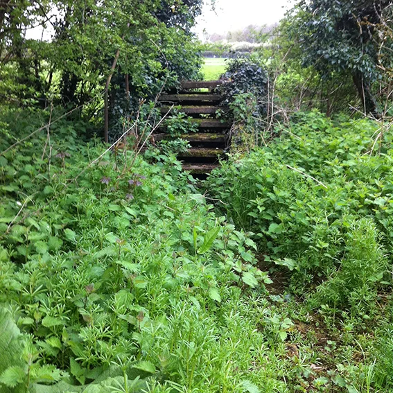
The detached steps leading to the dried up stream.

Cows in the field beyond the dried up stream. The low plastic fence usually indicates a piece of land set aside for development.

Looking back through the hedge at the rifle range.

The course of the Pudding Brook marked by the trees growing next to the field.

The Pudding Brook flowing away from Patterdown

The Pudding Brook looking upstream.